Highway Rock Cut Inventory and Slope Failure Potential, Allegany County, Maryland

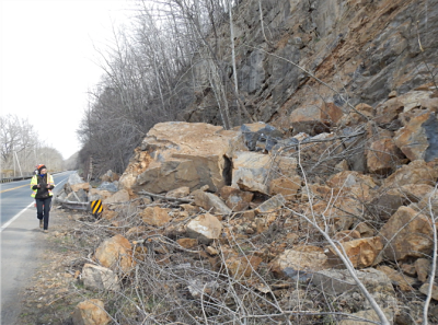
MDOT SHA highways of Allegany County, Maryland pass through inclined bedrock of varying compositions. These rock cuts consist of changing steepness and weathering levels that provides potential failure susceptibilities for rockfall, rock roll, rock slide, or slumping. Slope instability and bedrock failures can enter the roadway travel lanes presenting substantial hazard to drivers, and expense and liability to roadway agencies. To better understand the inherent risks of slope failure in these rocks SHA contracted the Maryland Geological Survey to conduct an inventory of State-maintained road cuts in Allegany County, recording various metrics of intrinsic and extrinsic slope characteristics.

195 rock cuts on MDOT SHA-maintained roads were located and inventoried. 189 of these rock cuts were located in Allegany County, while 6 were located in adjacent Garrett County. Inventory data was collected digitally on a tablet. Data acquired at each location included geographic coordinates, general description of slope, climate, and vegetation; and geologic character including bedrock failure planes, differential erosion, and rock type and orientation. A drone was used to obtain visible and infrared light imagery along MD 135 near Westernport, and at two locations on MD 51 near Spring Gap, to detect water and allow inspection of the upper slopes at these sites.

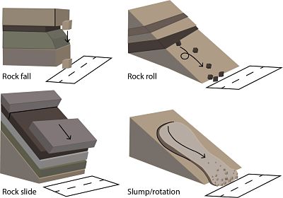
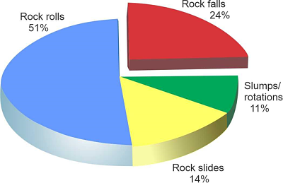
One of the main goals of the survey was to assess each road cut as to its potential for slope failure. Four types of potential slope failures were identified during the study: rock fall, rock roll, rock roll, and slump/rotation. The four types of slope failure identified (rock fall, rock roll, slides, and slumps) differed in numbers and prominence based upon four geologic factors. The main geologic factors creating potential slope failure are stratification, rock type, fracture character, and differential erosion.
The completed report MD-20-P01837G-1, Highway Rock Cut Inventory and Failure Potential, Allegany County, Maryland, is available from the MDOT research web site (https://www.roads.maryland.gov/OPR_Research/MD-20-P01873G1_AlleganyCountyHighwaySlopes_Report.pdf ).
Maryland Geological Survey, January 2021
Contact information
Maryland Geological Survey
Stephen Van Ryswick, Director
David K. Brezinski (410) 554-5526
[email protected]


